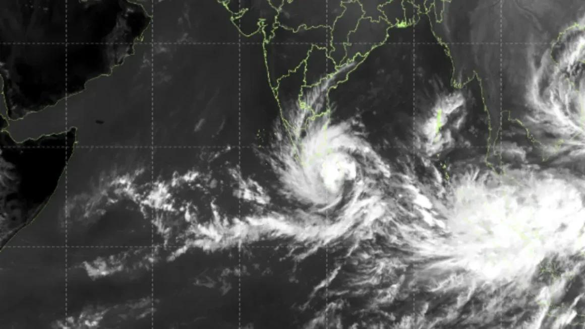
Cyclone Ditwah intensified steadily over the southwest Bay of Bengal on Saturday, moving closer to the Tamil Nadu coastline and setting off a chain of disruptions and emergency preparations across southern India and Sri Lanka. What began as a routine low-pressure area earlier in the week transformed into a powerful and fast-growing cyclonic system, raising fresh concerns for coastal districts already familiar with the destructive potential of severe storms.
The India Meteorological Department (IMD) warned that the cyclone would influence the region for at least five days, bringing heavy rainfall, strong winds, and choppy seas that could disrupt daily life and pose serious risks to vulnerable communities.
The first visible signs of Ditwah’s impact appeared at Chennai International Airport, where passengers on the Chennai–Colombo route faced long delays and uncertainty. Dense clouds, unstable air pockets, and rapidly shifting wind speeds made flying unsafe, forcing airlines to postpone or ground multiple flights.
The usually busy corridor between the two cities grew quiet as anxious travellers checked for updates while airport staff attempted to manage growing queues. Similar scenes unfolded in Colombo, where the storm’s outer rain bands had already begun affecting visibility and aviation operations. Airport authorities in both cities said they were closely monitoring the situation, and more delays were likely if the storm continued to intensify.
Outside the airport terminals, the mood across coastal Tamil Nadu began to change as well. In Chennai, the sky turned darker through the day, and intermittent spells of rain signalled the arrival of the approaching system. Local authorities moved swiftly, deploying disaster response teams, inspecting flood-prone neighbourhoods, and clearing stormwater drains to prevent potential blockages.
Past experiences with cyclones like Vardah in 2016, Nivar in 2020, and Michaung in 2023 have made the city particularly cautious. In many areas, residents began stocking up on essentials, preparing for possible power cuts or road closures in the coming days.
Further down the coast, districts such as Cuddalore, Nagapattinam, and Chengalpattu activated their emergency protocols. Fishing communities were among the first to feel the impact, as the rising waves and rough sea conditions forced fishermen to return early and halt operations indefinitely.
Many harbour areas remained unusually still, with boats tied tightly to the docks and families anxiously watching the sea. Officials advised people living near the shore to stay indoors and be ready for evacuation if required. Temporary shelters and school buildings were identified to accommodate those who might have to be moved from low-lying areas, and medical teams were kept on standby.
As the cyclone strengthened, meteorologists offered insights into why Ditwah was intensifying so rapidly. The Bay of Bengal, they noted, is one of the warmest ocean basins in the world, and in recent years, sea-surface temperatures have been rising even further. This warm water acts like fuel for Cyclone Ditwah, allowing it to develop faster and maintain high intensity for longer durations.
Satellite images over the past 24 hours showed Cyclone Ditwah expanding in size, with dense cloud tops, a tightening central circulation, and clear signs of rapid intensification. Experts warn that such sudden strengthening is becoming increasingly common due to climate change, and the region must prepare for more unpredictable and stronger storms in the coming years.
Sri Lanka, which lies close to Ditwah’s projected path, also experienced growing impacts. Colombo reported repeated rainfall spells, strong winds along the coast, and more flight delays as the storm influenced weather patterns across the island nation. Fishermen in northern and western Sri Lanka were instructed to remain onshore for at least the next two days.
Authorities have also appealed to residents to stay away from beaches, especially during high tide, as storm surges could be dangerous even without a direct landfall.
Back in Tamil Nadu, the government maintained that it was prioritising safety and preparedness. In Chennai, additional police personnel were assigned to manage traffic during heavy rainfall, and electricity boards began inspecting power lines in sensitive zones to prevent accidents.
Many residential areas, especially those located near lakes, canals, and rivers, were closely monitored to ensure that water levels did not rise dangerously.
Hospitals in major cities received instructions to keep emergency wards ready for any weather-related incidents, ensuring that medical help would be available even if the rains intensified.
As Ditwah moved closer to the coast, the IMD continued issuing regular updates on its speed, direction, and intensity. While the exact point of landfall was still uncertain, officials emphasised that the storm did not need to hit the coast directly to cause widespread impact.
The sheer size of the Cyclone Ditwah meant that rainfall and wind effects would be felt across a large geographical area, affecting everything from transportation and communication to fishing, construction, and power supply.
For now, authorities have urged the public to remain vigilant, stay indoors during heavy rain, avoid unnecessary travel, and follow instructions from local administration. With Cyclone Ditwah advancing steadily and gathering strength, Tamil Nadu and Sri Lanka are preparing for days of disruptions, while closely watching the skies for the next update from the meteorological department.
FOR MORE BLOGS – beyondthepunchlines.com

 Add to favorites


